All materials · map
Search the dictionaries, texts, images and API records available for this entry. Source matches are not curated endorsements.
Return to the curated articleSource / API coverage for this entry
Counts above cover loaded, permitted materials. Unavailable or not-yet-loaded sources are not evidence of an empty catalogue. Browser-only results remain on your device.
- Bing News · not loaded for this entry
- CineGraph · not loaded for this entry
- Wikimedia Commons · not loaded for this entry
- GIPHY · browser results · inspect complete records for status
- The Guardian · not loaded for this entry
- The Met · not loaded for this entry
- Open Library · not loaded for this entry
- Openverse · not loaded for this entry
- Pexels · not loaded for this entry
- PoetryDB · not loaded for this entry
- Spotify · not loaded for this entry
- Unsplash · not loaded for this entry
- Wikiquote · not loaded for this entry
Inspect complete source records and provider status
map
+2 variants
- /mæp/ Australia, General-American, Received-Pronunciation
- /map/ British, Northern-England, Scotland, Southern, Standard, Wales
- /mɛp/ New-Zealand
- recording
- recording US
noun
publication type or genre, visual representation of geographic space Wikidata where this came from — Wikidata
Definitions
3 dictionaries
 Samuel Johnson
18th century ·
1755 ·
noun ·
750 characters
A geographical picture on which lands and seas are delineated according to the longitude and latitude. Zelmane earnestly entreated Dorus, that he would bestow a map of his little world upon her, that she might see whethe
Samuel Johnson
18th century · 1755 · noun · 750 characters
A geographical picture on which lands and seas are delineated according to the longitude and latitude. Zelmane earnestly entreated Dorus, that he would bestow a map of his little world upon her, that she might see whethe
A geographical picture on which lands and seas are delineated according to the longitude and latitude.
Zelmane earnestly entreated Dorus, that he would bestow
a map of his little world upon her, that she might see whether it were troubled with such unhabitable climes of cold
despairs, and hot rages, as her's was. Sidney.
I will take the map of Ireland, and lay it before me, and
make mine eyes my schoolmasters, to give my understanding
to judge of your plot. Spenser on Ireland.
Read the rest of this entry · 267 characters Fold this entry
Old coins are like so many maps for explaining the ancient
geography. Addison on ancient Coins.
O'er the map my finger taught to stray,
Cross many a region marks the winding way;
From sea to sea, from realm to realm I rove,
And grow a mere geographer by love. Tickell.
Read this at Samuel Johnson where this came from — Samuel Johnson, A Dictionary of the English Language
 Open English WordNet 2025
2025 ·
noun ·
2 senses
a diagrammatic representation of the earth's surface (or part of it)
Open English WordNet 2025
2025 · noun · 2 senses
a diagrammatic representation of the earth's surface (or part of it)
-
●
a diagrammatic representation of the earth's surface (or part of it)
broader representation creation artifact whole object physical entity entity
-
●
(mathematics) a mathematical relation such that each element of a given set (the domain of the function) is associated with an element of another set (the range of the function)
Read this at Open English WordNet 2025 where this came from — Open English WordNet 2025
 Wiktionary (English) via Kaikki
2026 ·
noun ·
7 senses
A visual representation of an area, whether real or imaginary, showing the relative positions of places and other features.
Wiktionary (English) via Kaikki
2026 · noun · 7 senses
A visual representation of an area, whether real or imaginary, showing the relative positions of places and other features.
-
1
A visual representation of an area, whether real or imaginary, showing the relative positions of places and other features.
-
“Drawings and pictures are more than mere ornaments in scientific discourse. Blackboard sketches, geological maps, diagrams of molecular structure, astronomical photographs, MRI images, the many varieties of statistical charts and graphs: These pictorial devices are indispensable tools for presenting evidence, for explaining a theory, for telling a story.”
2012 March–April, Brian Hayes, “Pixels or Perish”, in American Scientist, volume 100, number 2, archived from the original on 19 Feb 2013, page 106
Wiktionary (English) via Kaikki
Plausible
-
“Anna, it is a map.”
2016, “Learning English (public domain)”, in (Please provide the book title or journal name), via VOA, archived from the original on 25 Sep 2017
Wiktionary (English) via Kaikki
Plausible
-
-
2
A graphical or logical representation of any structure or system, showing the positions of or relationships between its components.
-
“The 256 bytes of internal RAM are subdivided as shown in the memory map above.”
2005, Craig Steiner, The 8051/8052 Microcontroller, page 9
Wiktionary (English) via Kaikki
Plausible
-
“Creating a complete map of the human connectome would therefore be a monumental milestone but not the end of the journey to understanding how our brains work.”
2012 March-April, Terrence J. Sejnowski, “Well-connected Brains”, in American Scientist, volume 100, number 2, archived from the original on 27 Apr 2017, page 171
Wiktionary (English) via Kaikki
Plausible
-
- 3
show 4 more
-
4
Any of various nymphalid butterflies of the genera Araschnia (especially, Araschnia levana) and Cyrestis, having map-like markings on the wings.
-
5
The face. (UK, dated)
-
“And as the eye rested on him, he too filled me with pity and terror, for his map was flushed and his manner distraught. He looked like Jack Dempsey at the conclusion of his first conference with Gene Tunney, the occasion, if you remember, when he forgot to duck.”
1960, P. G. Wodehouse, Jeeves in the Offing, chapter X
Wiktionary (English) via Kaikki
Plausible
-
-
6
An imaginary or fictional area, often predefined and confined, where a game or a session thereof takes place.
-
“On top of that, each of Evolve's maps are dim, open arenas with little to interact with besides the occasional hostile organism.”
2015 February 14, Steven Strom, “Evolve Review: Middle of the food chain”, in Ars Technica
Wiktionary (English) via Kaikki
Plausible
-
“Maps are littered with little challenges in my pursuit of explorable shortcuts, treasure chests of gear, and statues that grant me more health.”
2025 February 26, Lauren Morton, “Review: Dragon Age: The Veilguard”, in PC Gamer (US), number 392, page 54; published online 28 October 2024
Wiktionary (English) via Kaikki
Plausible
-
-
7
Synonym of associative array.similar associative array
Read this at Wiktionary (English) via Kaikki where this came from — Wiktionary (English) via Kaikki
Examples
1 named by the record
-
1
filed as an instance of map by
 Wikidata
, none of them a word yet
 Urban Dictionary
read this at Urban Dictionary
Asking Urban Dictionary…
Crowd-sourced and unreviewed. Fetched by your browser; nothing is stored here.
Out in the world
5 things · every match says why it is here
Artworks
5
Saved catalog
-
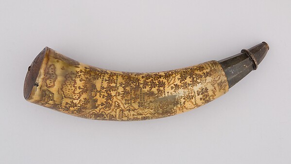
Powder Horn
dated 1759 Artwork
The Collection of J. H. Grenville Gilbert, of Ware, Massachusetts, Gift of Mrs. Gilbert, 1937
Open at The Met -

The Art of Painting
1667 Artwork
Johannes Vermeer
Jan Vermeer - The Art of Painting - Google Art Project.jpg · Wikimedia Commons
Open at Wikidata -

The Geographer
1668 Artwork
Johannes Vermeer
Johannes Vermeer, Der Geograf, 1669.png · Wikimedia Commons
Open at Wikidata -

Woman with a Water Jug
1660 Artwork
Johannes Vermeer
Jan Vermeer van Delft 019.jpg · Wikimedia Commons
Open at Wikidata -

Woman with a Lute
1662 Artwork
Johannes Vermeer
Vermeer - Woman with a Lute near a window.jpg · Wikimedia Commons
Open at Wikidata
Held since 17 Sep 2026.
GIFs
 GIPHY

Looking for GIFs…
Fetched by your browser on this visit; nothing is stored here.
Search matches, not reviewed interpretations. Hover, focus or press Play to animate.
Matches for “map” · About these results
Artworks
Saved catalog · The Met, Wikidata
Catalog matches from The Met, Wikidata, held locally rather than searched for on this visit. None is an accepted interpretation: a contributor connects an exact meaning and reviewers decide the claim. Browse saved artworks
- Powder Horn: Direct depiction of “map” (Q4006) tagged “Maps”. · not yet reviewed
- The Art of Painting: Direct depiction of “map” (Q4006) tagged “map”. · not yet reviewed
- The Geographer: Direct depiction of “map” (Q4006) tagged “map”. · not yet reviewed
- Woman with a Water Jug: Direct depiction of “map” (Q4006) tagged “map”. · not yet reviewed
- Woman with a Lute: Direct depiction of “map” (Q4006) tagged “map”. · not yet reviewed
Subjects
7 subjects · 0 addressed
Found by name and by the sources. Not reviewed: a shared name is not a shared identity.
Subject
map
publication type or genre, visual representation of geographic space
Unclassified
Subject
map
higher-order function in a programming language, which applies a given function element-wise to a collection (most generally, a functor instance)
Unclassified
Subject
Map
Wikimedia disambiguation page
Unclassified
Subject
map
parallel pattern idiom in parallel computing
Unclassified
Subject
Map
Unclassified
Subject
Map
painting by Jasper Johns
Unclassified
Subject
MAP
computer file type
Unclassified

map
publication type or genre, visual representation of geographic space
Wikipedia Q4006 where this came from — the thing this word names — map
In cartography, a map is a representation or abstraction of geographic reality. Maps are used for a wide range of purposes, including navigation, scientific research, governance, and warfare. A common use is route planning, which enables users to find their way to their destination. Specialized maps, called charts, are used for nautical navigation (nautical charts) and aviation (aeronautical charts).
… 2,499 more Fold this article
Scientists use maps to organize spatial data in fields such as geology, meteorology, seismology and demographics. Governments use maps for administrative functions such as census, electoral districts, property taxation, dispatching police, and coordinating disaster relief. Military and security organizations use maps for mission planning, surveillance, border management, logistics, and intelligence analysis.
One of the earliest preserved maps is from the Akkadian Empire (in modern Iraq) inscribed on a clay tablet and dated to 2300 BCE. By the 5th century BCE, Greeks were drawing maps of their known world, encompassing the Mediterranean Sea and most of Europe, North Africa, and the Middle East. Maps were important tools in the Age of Discovery, when mariners used them to explore new lands. Applications of cartography expanded in the late 17th century with the development of thematic maps, which portrayed specific kinds of data – such as rainfall or population density – rather than focusing on geographic features such as rivers, mountains, and cities. The rapid expansion of road networks and mass transit systems in the 20th century created a market for mass-produced maps aimed at the traveling public.
The development of computer cartography and geographic information systems in the mid-20th century enabled the storage of vast amounts of geographic data, which could be dynamically displayed and analyzed. Unlike paper maps, interactive maps let users zoom, pan, and choose which data to view. Geographic data used for mapmaking includes imagery, scanned paper maps, surveying measurements, geographic features, and terrain data.
Designing a map is a complex process involving the selection and arrangement of graphical elements to create a map that is informative, useful, and uncluttered. Because the amount of available geographic data often exceeds what can be effectively displayed, map designers must apply a generalization process to decide which elements to display and which to omit. The amount of detail is influenced by the map scale, expressed as a ratio between a distance on the map and the corresponding distance on the ground. The choice of a map projection is fundamental, as every projection introduces characteristic distortions. Geographic coordinates may be displayed as latitude and longitude, or in a Cartesian (XY grid) system. In addition to geographic data, maps may include supplemental elements such as legends, scale bars, north arrows, or inset maps.
 Wikipedia (English)
read this at Wikipedia (English)
where this came from — Wikipedia (English)
may also refer to
- map — publication type or genre, visual representation of geographic space
Public linked claims
What the existing sources assert about these meanings. These are source claims, not curated endorsements.
-
Growth-share matrix instance of map
Wikidata · assertion revision 1216302
Source, evidence and revision history -
A visual representation of an area, whether real or imaginary, showing the relative positions of places and other features. refers to map
Wiktionary (English) via Kaikki · assertion revision 3860568
Source, evidence and revision history -
map lexeme entity candidate map
Wikipedia (English) · assertion revision 1450959
Source, evidence and revision history
Sources
-
Samuel Johnson, A Dictionary of the English Language
Samuel Johnson
-
 The Met
-
Wikidata
Wikidata
-
Wikipedia (English)
Wikipedia (English)
-
Wiktionary (English) via Kaikki
Wiktionary (English) via Kaikki
-
Open English WordNet 2025
Open English WordNet 2025
-
GIPHY
GIPHY
-
Urban Dictionary
Urban Dictionary
8 sources on this page